Photogrammetry
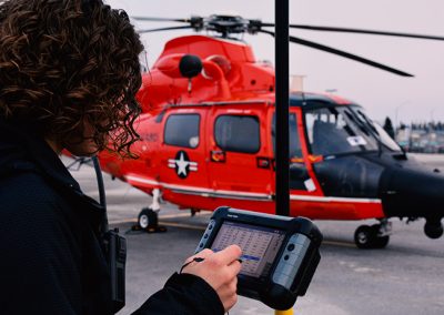
Our unique approach combines two data sets—from the air and ground—in a CAD-based environment for completion of quality control procedures and confirmation of accuracy.Geopro Consultants’ dual approach to many geospatial challenges results in a much better understanding of your project and world. Aerial photography, combined with our ground based surveying techniques, allows us to capture the full perspective on your project. Aerial imagery sees from the air what cannot be seen from the ground; this top-down perspective is the best method for collecting tree tops and difficult terrain. Meanwhile, ground-based terrestrial surveying can be used to collect the difficult to capture man-made obstacles, such a flagpoles, water sprinklers, and utility information that is impossible for a photogrammetry-only firm to measure. Our unique approach then combines the two data sets in a CAD-based environment for completion of quality control procedures and confirmation of data accuracies.
Geopro regularly works with imagery acquisition firms throughout the nation to collect on-demand aerial photography for topographic mapping, terrain and obstacle assessment, and many other project types. We utilize firms located in close proximity to project areas, drawing upon local knowledge of pilots and operators, allowing them to collect the imagery efficiently and at the best available cost for our clients.
The capabilities of our skilled photogrammetrists are not limited only to traditionally-captured aerial photography. Our team routinely acquires satellite-based imagery to complete projects across the globe. Working with our industry partners, including Astrium, DigitalGlobe, and GeoEye, we can quickly task and acquire images of your site from more than 400 kilometers (250 miles) above earth. The imagery results in 50-centimeter resolution and is suitable for the generation of many datasets, including most man-made obstacles, terrain (including e-TOD), and collection of planimetric features.
Geopro is also now exploring drone-based survey data collection approaches and has developed numerous algorithms for the analysis of data collected from unmanned aerial systems. The accuracy of any data set, no matter how collected, can only be assessed by comparison with known true values. Our unique ability to collect highly-accurate survey data as a benchmark validation tool can help you have confidence in this new technology.
The aerial imagery collected by Geopro can be utilized to create a wide variety of products to help your organization better understand your project, including orthophotography, topographic mapping, digital elevation models, as well as complete 3D models. Our data can be made easily accessible in a variety of formats and systems, including paper-printed maps, custom mobile tablet applications, and even 3d sculpted models at a variety of scales. At Geopro, our goal has always been to make challenging data more accessible and easier to understand. Our wide array of data formats and deliverables ensures that no matter your level of experience with geospatial data, you’ll receive a product that is perfectly tailored for your organization.
Please feel free to contact the Geopro Team today to discuss your project’s challenges and get a free assessment of how we can help realize your goals.
Insights in Photogrammetry
An evaluation of drone accuracy for obstruction mapping
Drone technology offers a lot of promise, it cannot be exclusively relied upon.
The reality of PhoDAR
I’ve been hearing the term PhoDAR (photogrammetric detection and ranging) a lot lately. There are numerous automated “photogrammetry” software packages being offered today that create point clouds from photos. The software looks phenomenal and many boast of incredible...
e-TOD
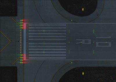
Geopro Consultants offers complete e-TOD (Electronic Terrain and Obstacle Database) production and management for airports to ensure compliance with international quality requirements for terrain and obstacle data including ICAO Annex 15 up to Amendments 33, 34 and 36...
Case Studies in Photogrammetry


Geopro Consultants, LLC
704 Brown Street
Dayton, Ohio 45402
(937) 674-1492