I’ve been hearing the term PhoDAR (photogrammetric detection and ranging) a lot lately. There are numerous automated “photogrammetry” software packages being offered today that create point clouds from photos. The software looks phenomenal and many boast of incredible accuracy. Wikipedia currently lists more than 60 such solutions, with big name vendors such as AutoDesk, Bentley, Microsoft, and Trimble on the list.
These software solutions utilize camera based techniques that rely strongly on a workflow called Structure from Motion (SfM). During the SfM process, 2-Dimensional photographs of a scene are obtained from many different perspectives, the software then analyze the photos looking for similar features and patterns. Using this redundancy the software estimates a camera calibration as well as transformations between the different camera views. Typically this is done in multiple steps with an initial “sparse processing” to determine camera and view parameters, and then a “dense reconstruction” is performed that processes the images in overlapping chunks. This technique is computationally intense, but uses statistics to estimate reality and come up with a point cloud. If the same pattern matches in multiple photos a level of confidence can be estimated that point actually exists… even if it doesn’t.
I’ve been exploring this technology for nearly a decade and it has been interesting to see the market develop. In one recent Whitepaper eBee (using Pix4D I’m guessing) claims they can achieve an accuracy of 3 cm (Horizontally) to 5cm (Vertically). My guess is the key word there is “can.” Just because it can be done, doesn’t mean it is done. (How’s that for a sentence?)
If you’ve ever tried out this type of software you’ll notice glaring issues if you look at the data closely. An example of this is provided below. The far left is a photograph of the actual pole, the middle data was collected with our Faro terrestrial scanner, and the far right was computed using a very popular (and expensive) software SfM/PhoDAR/Photogrammetry package. Reality and LiDAR are very clearly in agreement, but the limitations of structure-from-motion based solutions are apparent. This point cloud was computed using 30+ images at an altitude of 150 feet (more to come on this example later).
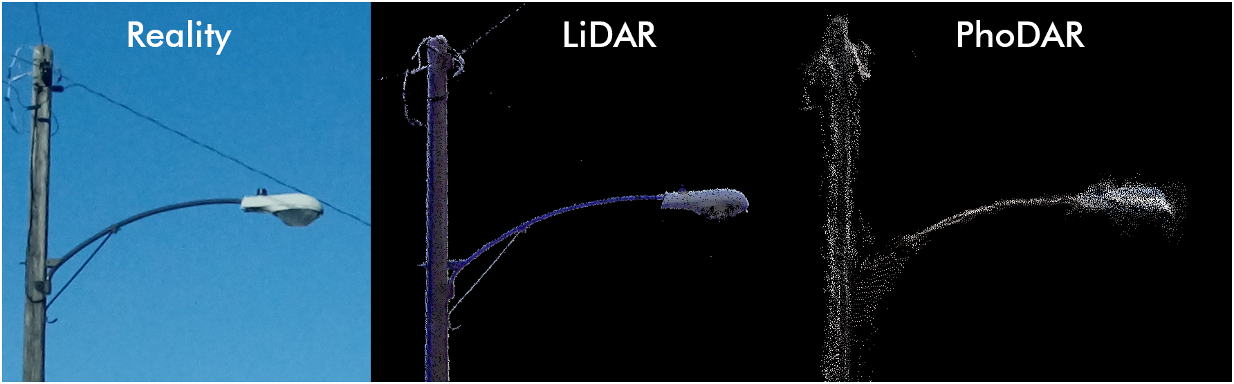
One of these is not like the others.
It is interesting technology and those high-altitude demo videos I keep seeing are impressive, but I don’t think it’s quite a substitute for professional grade mapping. As this software becomes more accessible, there’s a potential danger to the public when used by drone owners who may not know the limitations. Be careful out there and stay informed, check back here often for more on this topic as we continue to explore new geospatial technologies.
PhoDAR Light Pole Sample
by geopro
on Sketchfab
LIDAR-TENTH
by geopro
on Sketchfab
Please comment below and share your opinion on PhoDAR and other automated photogrammetry solutions. Does automated photogrammetry pose a risk to the public?
I think surveyors are at a critical point right now. The word “survey grade” is tossed out there by unlicenced drone operators that don’t know the first thing about CM(or two) level positioning. Also, they are claiming to do the work of a ground survey crew at a fraction of the time/fee.
I think the NSPS needs to trademark the term “surveyor” much like the national association of realtors did for their profession. That way people couldn’t claim to be doing a “survey” unless you were a “surveyor” . Will it happen, who knows… but I hope surveyors show some leadership in this field before it’s too late.
Excellent article. Thank you for sharing.
I think, from a “typical user” perspective, there are few private users that will process data in this way and use it for things like…say, “sense-and-avoid.” There might be a danger if private users are attempting to use the software for applications of that type. If, however, a private user is willing to invest the capital to obtain something like Pix4D, they’re probably going to use it to build cool 3D models just to look at and share (low potential for danger).
A bigger concern might be commercial users who are basing autonomous flight planning off of 3D terrain models out of PhoDAR packages. As you’ve pointed out, the accuracy of the data is not good enough, nor mission planning softwares capable of integrating the data, in order to use it for autonomous route planning. Combining the use of processed PhoDAR data with a robust sense-and-avoid capability might help, but I would still be wary of employing PhoDAR models in this way.
As a professional in the Intelligence, Surveillance, and Reconnaissance (ISR), and UAS markets, and the Search and Rescue Imagery collection analysis community, PhoDAR is at best a good pre/post-mission area/data visualization tool. I wouldn’t use the models to gather geographic point information or vector search teams without the benefit of supporting information (e.g., accurate maps, DTED, DEMS, Google Earth, up-to-date imagery, etc.).
My biggest concern is the use of image data from UAS platforms for Search and Rescue. Anyone can collect image data using a UAS and purport to know what they see in the imagery. They may send Search and Rescue teams into an areas based off of their imagery calls. The idea of untrained analysts potentially putting searchers in harms way based upon a call from an untrained eye is frightening. As an imagery analyst, having worked with untrained volunteers on Search and Rescue missions, I am intimately familiar with the challenge of the untrained eye. I’d love to address that issue with training.
Excellent perspective. Thanks for posting.
Have you taken a look at this application: https://www.dronedeploy.com/
Do you have any feedback?
Aerial based LiDAR beats photo every time
We have used UAS (Drone) phtogrammetry for several projects. We have in in house survey crew with a licensed land surveyor and have done ground-truthing on all of these projects with GPS and traditional instrument survey. We are consistently achieving 3cm horizontal and 5cm vertical accuracy and that is the outside range of our error. We are consistenly getting within 1cm horizontal and 2cm vertical accuracies. These are for parcel around 70 to 100 acres.